Archive for April 2009
Chesapeake and Ohio Canal
At 3AM on April 25, 2009, I will join several hundred other participants and attempt to walk 100 kilometers (62 miles) in one day along the C&O Canal towpath, from Georgetown, D.C. to Harper’s Ferry, West Virgina. To mentally prepare for this foolhardy attempt, I thought I’d briefly walk through the canal’s history.
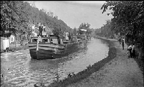
Courtesy of the NPS
The canal’s history as a functional transport artery is something of a prolonged tragedy. The story begins, like most tragedies, with a seemingly idyllic birthright: the canal was first championed by none other than George Washington, who also, it should be remembered, championed such things as non-partisanship, presidential term limits, and the United States of America. Apparently in his younger years, George was something of a canal enthusiast, going so far as to introduce a 1774 bill in the Virginia legislature to construct canals around obstacles in the Potomac River. Even in his presidency, George continued to lobby hard for a canal extending from the nation’s capitol and viewed it as a critical piece of his broader vision for consolidating national cohesion and opening up commerce and communications with the west:
‘”Extend the inland navigation of the eastern waters; communicate them as near as possible with those which run westward; open these to the Ohio; open also such as extend from the Ohio towards Lake Erie; and we shall not only draw the produce of the western settlers, but the peltry and fur trade of the lakes also, to our ports: thus adding an immense increase to our exports, and binding those people to us by a chain which never can be broken.’”
From Memoirs of De Witt Clinton, transcribed by Bill Carr

Armed with the ringing endorsement of one America’s most hagiograph-ied figures, the future C&O Canal looked destined to join the ranks of Route 66, the Union Pacific Railroad, and, yes, the Erie Canal, in the annals of transportation lore. By the 1820′s, a perfect storm brewed. The case for the C&O Canal was buoyed by the lucrative success of its northern cousin. Proposed in 1808 and beginning construction in 1817, the Erie Canal took little time to start turning a profit as toll revenues poured in from already-completed sections. The Canal had a profound effect on the region and country, establishing New York City as the nation’s premiere commercial center and acting as a poster child for the infrastructure boom of the 1820′s.

The Erie Canal
Digging a little deeper (pun intended) however, revealed fundamental weaknesses underlying the C&O Canal’s prospects to follow in the Erie’s footsteps. Construction began in 1828, as John Quincy Adams dug the first spadeful of earth. Fittingly for the canal, his attempt at ceremonial ground-breaking met with an unforeseen obstacle:
“It happened that at first stroke of the spade it met immediately under the surface with a large stump of tree after repeating the stroke three or four times without making any impression threw off my coat and resuming the spade, raised a shovel full of the earth at which a general shout broke forth from the surrounding multitude and I completed my address which occupied about fifteen minutes.”
John Quincy Adams
JQA Diary, number 36, 1 January 1825-30 September 1830, page 21
Beginning with this nearly-bungled case of presidential midwifery, it was all downhill from there. Five years after its construction, the canal had only progressed 60 miles, and was not yet fully operational. In hindsight, beginning construction on a canal in 1828 was poor timing. The meteoric pace of internal improvements during this period may have spurred the impetus for building the canal, but also created an infrastructure bubble that left it open to significant competition and unrealistic expectations.
In particular, the canal found itself embroiled with the Baltimore & Ohio Railroad over land-use rights along the Potomac. Although the two sides settled their dispute, the legal wrangling was symptomatic of the canal’s slow-going construction and never-ending obstacles. The B&O Railroad, which began construction on the same day as the C&O Canal, progressed far smoother, and provided a significant advantage to its clients in speed of transport. The C&O finally reached Cumberland, Maryland (linking it to the National Road) and promptly ceased construction. The B&O Railroad completed the all-important link to the Ohio River in West Virginia in 1852, usurping the canal’s purpose and rendering the slow-moving waterway somewhat moot. Which is why the B&O Railroad, instead of the C&O Canal, garnered eternal fame as a one of Monopoly’s prized properties:

The canal remained nominally operational until 1924, when a catastrophic flood wreaked havoc on the transport system, and in 1938 the canal was sold to the federal government. By the 1950′s, in the wake of another national transportation boom, Congress entertained the idea of paving over the canal to build a scenic road for automobiles. Fortunately for canal lovers, Supreme Court Justice William O. Douglas assumed the mantle of George Washington to become the canal’s next great champion in Washington.
In an impassioned letter to the Washington Post in 1954, the nature-loving Douglas channeled his inner John Muir when he wrote, “It is a refuge, a place of retreat, a long stretch of quiet and peace at the Capitol’s back door – a wilderness area where we can commune with God and with nature, a place not yet marred by the roar of wheels and the sound of horns.” He then threw down the gauntlet as only a tree-hugging Supreme Court Justice of the 1950′s could do: by challenging proponents of paving the canal to walk its entire 184.5 miles with Douglas as their guide.
Perhaps to Douglas’s surprise, his challenge was not only accepted, but snowballed into a media spectacle. Fifty-seven people joined him on March 20, 1954 to begin hiking the trail. Although only nine of them finished the eight-day hike (many were discouraged by a snowstorm on the second day of the trip), Douglas’s expedition garnered national attention, as flocks of reporters interviewed the justice and his hikers, and onlookers showered the walkers with cheers and food. By the conclusion of the hiking circus, public support had swung towards preserving the C&O Canal.
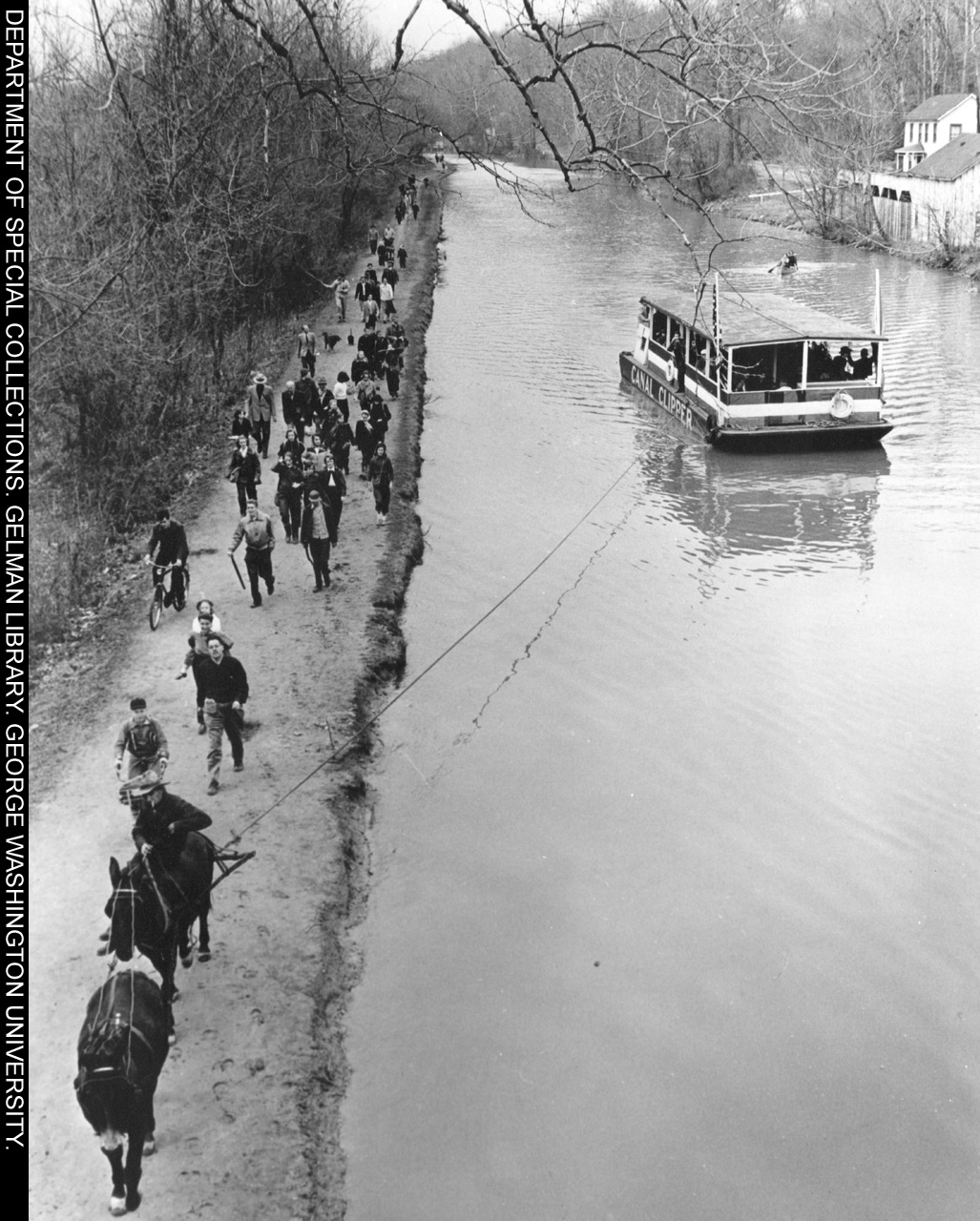
The C&O Canal Expedition
The publicity stunt ended up saving the canal, and in 1971 the federal government designated the C&O Canal a National Historic Park. Today the canal remains a popular get-away for D.C.-area residents, who can walk, bike, jog, kayak, or in Douglas’s words (if they are in a particularly spiritual mood), “commune with God and with nature.” When plodding along the canal on Saturday, I will try to remember a poem stanza composed by Douglas’s hikers while on trail:
The knees are slowly playing out
The arches start to drop;
If we had John Brown’s body here,
We’d like to make a swap.

William "Keep Your Hands Off My Canal" Douglas
AAHC Recap (Afternoon)
The first session of the afternoon at the AAHC conference was by Patrick Murray-John as he discussed “Interlinking Who, What, Where, When, Why, and How We Teach into a Giant EduGraph.” He gave an entertaining presentation that described the benefits and challenges of a semantic web within education. One story stood out in particular as an example for the need for better efforts in the field. Two courses might use Frankenstein as an assigned text: a class in the chemistry department that examined the portrayal of scientists in literature and an introductory English literature course. Unfortunately, the only people who know that both classes are using the same text is the school book store. If the course syllabi were located within a strong semantic web, there could be tremendous potential for interdisciplinary discovery and interaction within a university.

The second session of the afternoon was “Mapping Our Archives,” by Tim Sherratt of the National Archives of Australia. Sherratt gave an incredible presentation, as he demonstrated his work with the records of Australian servicemembers during the First World War in Mapping Our Anzacas. First up, he used Google Earth to show how he mapped where each of the 300,000 plus soldiers were from. It was remarkably powerful, as he used the platform dynamically in order to visualize the origins and density of this segment of the population. In particular, I was struck at how effectively it took advantage of the interface of Google Earth, and its re-population of point data when you zoom in, so even as you get more and more detailed, it seems like the dots just keep multiplying. The map was one point of entry for users of the database, with another critical point of entry being the opportunity for users to upload multimedia to a “scrapbook” of individual servicemembers profiles. Although some curators expressed (standard) anxiety about losing credibility and content control, they were overwhelmed at the number and quality of contributions from “laypeople,” such as this one of Donald Addison:

Tim also shared his crafting and tweaking of the database for the servicemembers’ records. Each record was scanned, and many of them included photographic sets of the individuals along with vitals and descriptions of their service. He then used CoolIris (which I discussed in one of my first blog posts) to create a virtual gallery of these archival documents, as you could move along a 3-D wall with rather haunting profile photographs and corresponding information (almost like an early 20th-century version of Facebook). He also showed a similar application of CoolIris for other archival records, including those of immigrants and laborers. I’ve always been somewhat skeptical of CoolIris as a visualization technique, always thinking it did little more than create a kind of cool way to zoom around and look at pictures. But Tim substantially changed my mind by demonstrating its power as an interface – without a doubt, being able to see an array of documents displayed in front of you, seeing the faces of Chinese immigrant children looking out at you, was a singularly powerful use of archival material that significantly enhanced the viewer’s interaction with them.
Tim’s presentation got rave reviews from its audience members, and I think I speak for all of them when I say that his use of dynamic technical interfaces (which included not only Google Earth and CoolIris, but also Tumblr and Greasemonkey scripts) was one of the most elegant, powerful, and accessible examples of bringing archival material to life that I’ve seen yet. Tim offered a fantastic glimpse into what is possible when you combine the power of digital applications with the subtlety and thoughtfulness of historical exploration.
The final session of the afternoon was a presentation from Susan Garfinkel, Judy Graves, and Jurretta Heckscher from the Library of Congress. Although I was a little fried from seven hours of absorbing and processing a host of new thoughts and ideas, I always love supporting our friends at the LOC, who have put a lot of time, thought, and effort into advancing and experimenting with digital history. Their presentations brought up several interesting points. First, they stressed that a series of surveys have shown that faculty members are less than enthusiastic about actually utilizing digitization tools and resources that their libraries provide. Additionally, the LOC has decided to expand their earlier initiative to post photographic content on Flickr Commons by posting audio and video content to iTunes and YouTube. The presentation reinforced my optimism that our national library has the courage to pursue such a variety of digital initiatives.
I drove out of George Mason’s campus feeling exhausted and inspired. The conference did a superb job of bringing together and enhancing a community of digital humanists (made even stronger by the constant Twittering activity during the day). This community isn’t necessarily representative of either the general public or even the wider historical community – in particular, I was struck at the rather overwhelming whiteness of the conference participants. I think more efforts could be made to encourage a wider diversity of perspectives and backgrounds within the field of digital history (a subject for another blog post). Nevertheless, the range, depth, and passion with which so many people are pursuing their projects gives me a strong sense of hope. I know that over the next several years I will undoubtedly struggle to balance the demands of training in a traditional graduate history program with my own passion for digital methodology and exporation. But events such as the AAHC conference bolster my faith in the incredible support system of fellow digital humanists that I can lean on as I walk down that path.
AAHC Recap (Morning)
Today I attended the American Association for Historical Computing‘s 2009 annual conference, hosted by the Center for History and New Media at George Mason University. For someone interested in the field of digital history, it was a phenomenal opportunity to meet fellow enthusiasts and explore a variety of topics within the field.
The first session, a presentation by Amanda French of NYU on “Basic Digital History Skills for Historians,” came from her experience in teaching courses in digital history, many geared towards archival and library studies. Of particular interest was a survey she administered to 25 students that measured their comfort and ability in a wide variety of digital skills – everything from using social media to knowledge of metadata systems. She spoke about the fact that there was a gap between the skills being taught to public historians and archivists, and those being taught to traditional historians. Namely, those in the former group usually gain a stronger digital literacy. One of the major action points she drew from the survey was the need to teach students in the following fields: website creation, metadata, and multimedia.
Besides being the first conference presentation that I’ve live-tweeted, it brought up some interesting questions. The biggest one (that recurred throughout the day) was the question of teaching students what I’ll term hard vs. soft skills in gaining digital literacy. Should teachers expect their college students to have a basic skill set (uploading videos onto YouTube, using RSS feed readers, etc.) already? Should you spend the majority of your time teaching the skills and habits that they can then adapt to specific platforms? Is it possible to impart broader concepts of digital history without a concrete base in technical proficiency? My first instinct was to come down on the side of a liberal-artsy instruction of soft skills and underlying “big-picture” principles. But the more I thought about the issue, the more I realized that for many people, the best way of learning these soft skills is by putting on your work gloves and diving into starting a blog, using Zotero, or generating a KML file.
The second session was Dave Lester‘s “Mobile Historical Landscapes: Exposing and Crowdsourcing Historical Landmarks.” Dave explained his ongoing project (History Plot) to create a means for people to contribute to a geolocated database. He compared it to Yelp, in that he dreams of a centralized platform through which people can look up historical landmarks and their metadata (primarily their location). In order to start seeding History Plot, Dave turned to 80,000 historic sites listed in the National Registry of Historic Places. Other resources could include Wikipedia, Flickr, and partnerships with local historical societies.
Dave’s enthusiasm was downright infectious, as he spoke about being able to walk down a city street, use your iPhone to locate a nearby historical building, look up information about it, then take a photograph of it and immediately upload it to the database. Possibly the most exciting aspect, for me, was his idea of leveraging community-based history volunteers (he calls them “street teams”) to crowdsource the project. I think this has tremendous potential. History remains one of the foremost fields for armchair enthusiasts, as legions of geneologists and Civil War re-enactors would provide an incredible resource for this kind of geo-based crowd sourcing. It’s easy to imagine groups of history buffs meeting up on the weekends to explore cities and sites, snapping pictures and contributing research tidbits. I’d love for this to get off the ground, and would jump at the chance to found a local chapter.
Dan Cohen brought up a good point at the end of Dave’s talk: that the issue is finding an incentive structure so that people will actually participate in the project. In particular, there’s a gap between the (usually) younger tech-savvy crowd that lacks a strong interest in local history, and the (usually) older, less tech-savvy crowd that could potentially be the strongest source for knowledge seeding. I think it’s a manageable problem, but one that increases the need for highly accessible mobile technology and platforms that makes the barriers to entry as low as possible, even if it has to come at the cost of losing some technical robustness.
The last session of the morning was “Teaching, History, and Digital Tools: A Roundtable Discussion,” by Jeremy Boggs, Jeff McClurken, and Josh Sternfeld. All of them brought different perspectives to the topic, although each of them came from the similar experience of having taught a digital history course. It was a similar presentation to the one given by Jeremy and Jeff at the AHA convention, and it reinforced a lot of the lessons they had previously given (chief among these is Jeff’s great refrain about trying to make students “uncomfortable but not paralyzed”). One point that it made me think about was the issue of how to value historical scholarship. I’ve been thinking a lot more about not only how the historical academy values research in digital history, but how it values teaching in digital history as well. Does listing “Creating History in New Media” on your C.V. as a course you taught carry more weight than listing an American history survey? Would a tenure review board be impressed with your tech-savvy literacy, or put off because they don’t understand it?


